Advanced Search
Login
Forgot pass?
Remember Me?
Register
What's New?
Forum
New Posts
FAQ
Calendar
Community
Groups
Albums
Member List
Forum Actions
Mark Forums Read
Quick Links
Today's Posts
View Site Leaders
Who's Online
Gallery
Classifieds
Advertising
Events
Articles
Forum
General Discussion Area
The Sandbar
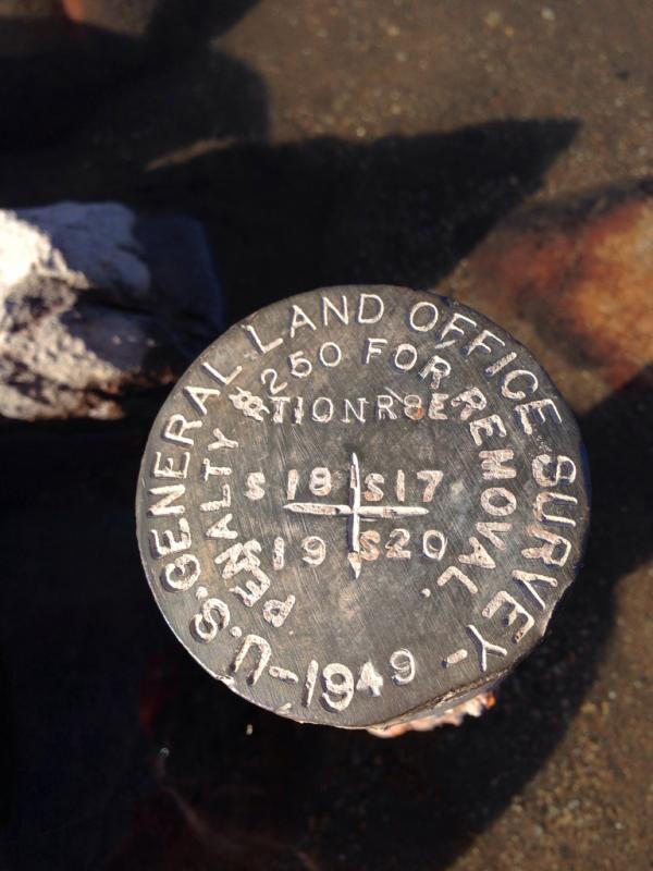
Can anyone tell me where I am at?
If this is your first visit, be sure to check out the
FAQ
by clicking the link above. You may have to
register
before you can post: click the register link above to proceed. To start viewing messages, select the forum that you want to visit from the selection below.
Results 11 to 20 of 36
Thread:
Can anyone tell me where I am at?
Thread Tools
Show Printable Version
Search Thread
Advanced Search
Display
Switch to Linear Mode
Switch to Hybrid Mode
Threaded Mode
Threaded View
Previous Post
Next Post
01-24-2014,
05:34 PM
#1
GRADS
Guest
Can anyone tell me where I am at?
Any guesses?
Reply With Quote
Quick Navigation
The Sandbar
Top
Site Areas
Settings
Private Messages
Subscriptions
Who's Online
Search Forums
Forums Home
Forums
Announcements
Hotboat Announcements
"How To"
Sponsor Shop
General Discussion Area
The Sandbar
Hot Boat Videos
Hot Boat Girls
Water Skiing
Ski Racing
Recreational Skiing
Wakeboarding
Photography
Boating Events
Finance and Insurance
Race Organizations
Manufacturers
Hotboat, Hot Rods, Hot Toys
Hot Boat of the Month (member vote)
Hotboat rides
Hot Toys
Tech Section
V-Hulls
Cats
V-Drives
Marine Engines
Outboards
Jets
Jet Boat Performance
Big Blue
Audio
Gel, Paint & Upholstery
Propulsion
Engine Builds
Off Shore Only
V-Hulls
HOTBOAT Lifestyle section
Off-Road
On-Road
Guns - long and short
Whats Cooking?
Great Outdoors
Fishing
Guns/Hunting
Now Hiring
Regional Forums Section
East Coast
North
South
Great Lakes Area
Mideast
Midwest
West Coast
Havasu
So-Cal
Parker Strip
Lower River
Norcal
Abroad
For Sale Listings
Boats for Sale
Parts for Sale
Other Stuff For Sale
Trailers and Trailer Parts
ATV, Offroad, Dirt Bikes
Tow Vehicles, Cars and Parts
Homes for sale, rent or lease
Advertisers
Site Support
General Support
Testing Area
Articles
«
Previous Thread
|
Next Thread
»
Bookmarks
Bookmarks
Digg
del.icio.us
StumbleUpon
Google
Facebook
Twitter
Instagram
Posting Permissions
You
may not
post new threads
You
may not
post replies
You
may not
post attachments
You
may not
edit your posts
BB code
is
On
Smilies
are
On
[IMG]
code is
On
[VIDEO]
code is
On
HTML code is
Off
Forum Rules


 Reply With Quote
Bookmarks